Radha Agarwal, Local Journalism Initiative, The Northern View
This winter, Prince Rupert is having a colder and more arid season than usual, and this trend might last until mid-February.
“In January, we definitely got much drier. January 1 to January 31 we only had 70 per cent of normal precipitation,” said Derek Lee, a meteorologist at Environment and Climate Change Canada.
While the rainy city typically receives 276.3 millimetres of rain in January, this year, it got just 193.6 millimetres.
Lee notes that winter is usually the wettest season for coastal communities like Prince Rupert.
“We count on this time of year to replenish the water supply and the snow pack of the mountains…This is the prime time to do it, so if we’re not getting it now, then there could be some consequences later on in the year in terms of drought,” said Lee.
“Leading into the first week of February, we are seeing the temperatures being around five to 10 degrees below normal right now.”
Derek Lee, meteorologist at Environment and Climate Change Canada
Rupert also saw a cooler end of January than usual.
“Leading into the first week of February, we are seeing the temperatures being around five to 10 degrees below normal right now,” said Lee.

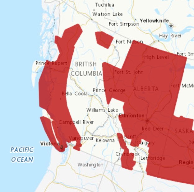
Additionally, the coastline is under an Arctic Outflow Warning, which could last until the weekend.
“There’s some strong winds going out throughout the North Coast,” said Lee. “These can create a wind chill effect that makes temperatures feel as low as -20 degrees, increasing the risk of frostbite from skin exposure. Nighttime temperatures will be the coldest.”
When Arctic air dominates the province, it will be under a ridge of high pressure during this time. High pressure tends to bring sunny skies and dry days, reflecting storm patterns away from BC. As a result, there may not be precipitation in Rupert due to the presence of cold Arctic air. Some snow is possible, but no rainstorms are forecast until mid-February.
“The Rupert area and BC are experiencing La Niña weather conditions this year.”
Derek Lee, meteorologist at Environment and Climate Change Canada
Looking ahead to the latter half of February, there might be a slight moderation in cold temperatures, but a cold signal will likely continue for BC.
“The Rupert area and BC are experiencing La Niña weather conditions this year,” said Lee. “So what it usually does is just it brings colder than normal temperatures for BC with a… 59 percent chance this condition might continue until Spring.”
Despite currently experiencing La Niña, its intensity is weak in 2025. Therefore, people may not encounter the freezing temperatures observed in previous La Niña years.
“Eventually, this cold will move away. Once we get more storms from the Pacific, it will start up the warm weather again,” said Lee. “So all we need is just some Pacific storms to come in to actually make the temperatures feel more normal, so that can come into the later part of February, once the arctic air is out of the way.”


